


P U B L I C I D A D E


A Bridge to the future
The design of the bridge that connects the city of Salvador to the Island of Itaparica a new milestone in Brazilian engineering and a virtual inducer of social and economic development for the region starts to become real
The contract for the basic design of engineering of the Salvador-Ilha de Itaparica Bridge was signed in the beginning of March. The document was signed by the Government of the State of Bahia and the Consortium composed by Brazilian companies Enescil and Maia Melo and by the Danish company Cowi. The selection was the result of an international bidding that considered for classification purposes criteria such as technical capacity of the bidders and price proposed for the works. The winner presented a proposal of design development by a price of R$ 22.5 million, what represented a discount of 15.4 percent over the initially estimated price.
The Service Order for the start of basic engineering design was already issued and the consortium will present intermediate and final studies until October of this year. One of its tasks is to propose alternatives for the path of the bridge and the road that will be built in its sequence, in the Island of Itaparica. The consortium will also carry out the engineering draft and the report that will support the Environmental Impact Study (EIA) that is being developed by another international consortium composed by the companies V&S Ambiental (Brazil) and Nemus (Portugal).
This second consortium won the bid for carrying out the EIA and the Environmental Impact Report (Rima) referred to the works of art, at a cost of R$ 7.2 million. The EIA and Rima are considered fundamental instruments for minimizing the environmental and social impacts, mainly in the Island of Itaparica, in the Bay of Todos os Santos and in the other areas affected in the Recôncavo Baiano. In accordance with the edit, the studies include an environmental diagnosis and the proposition of plans and programs of mitigation and compensation of environmental impacts.
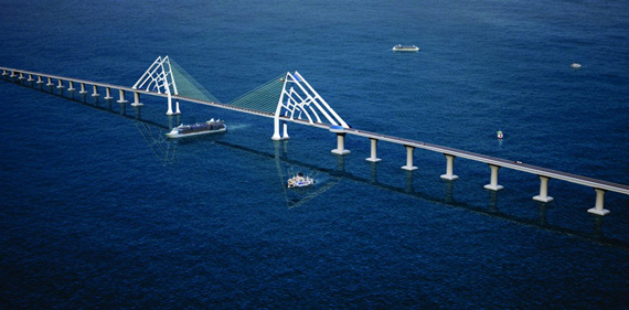
The original project—coordinated by the Department of Transport Infrastructure of Bahia (Derba) and by the Secretary of Planning of the State Government (Seplan)—was proposed by a consortium composed by OAS, Camargo Corrêa and Odebrecht Transport. It foresees the construction of a 12-km bridge with a 700 m section of cable-stayed bridge and a mobile section of 160 m to allow the passage of large vessels. The estimated cost of the project is R$ 7 billion and in principle works will be carried out in a period of four years.
In its original concept of design, the project includes the construction of a bridge with six lanes for traffic and two for road shoulder, in a total width of 27 m. The cable-stayed section will be 70 m high and 25 m deep. This span will be sustained by two masts of triangle-shaped section following the inclination of the stays. A belvedere will be built at the top of each mast, with access through cable cars.
The pillars of the bridge will have a distance of 200 to 250 m between each other to ensure the landscape view. In the section designed to be mobile, allowing the passage of large vessels and even oil platforms, the runway structure will turn on its own axis. The traffic flow will be interrupted during this operation.
Transport and mobility
The proposed path will start near the harbor of Salvador and will reach the Gameleira region, in the Island of Itaparica. The initial proposal establishes that the bridge has to allow full navigation in the Bay of Todos os Santos (BTS) and full access to the harbor of Salvador. There is still the possibility of an alternative for mass transport that will have its feasibility analyzed in the engineering studies. An analysis of traffic demand will be carried out for the design of the road system. This analysis, together with navigation studies in the Bay of Todos os Santos and of the impacts of the bridge on the harbor of Salvador will also be part of the basic engineering design. All these documents will allow the evaluation of the effects of the project on the whole region. The studies will contain also an evaluation of the social and economic impacts of the project, such as questions referred to water, sewage and solid waste caused by the larger occupation of the island.
The schedule of actions for this year includes the contracting of survey, engineering, environmental and urbanism studies. It is also programmed the formation of an agreement for the studies of sea hydraulics and a bid for cultural and immaterial studies.
A polemic project
In spite of all arguments of the state government on behalf of the bridge, works are far from get unanimity of the population, dividing opinions. On one hand are those who have fear of the consequences of the environmental impact and censure the “loss of characteristics” of the Bay of Todos os Santos with this enormous concrete structure. On the opposite hand are those who are in favor of modernization as a factor of development for the 24 municipalities involved, which will reduce their distance to the capital in until 40 percent.
An elitist, expensive, unnecessary, megalomaniac work, a “white elephant”. These are only some of the classifications given to the project by their opponents. The bridge will be the second of South America and the 23rd largest in the world.
The State government minimizes the critics ensuring that the project preserves aesthetic patterns compatible with the landscape. But much stronger than the comments of the government are the considerations of those who remember that—40 years ago—the same critics were heard about the Rio-Niterói Bridge. Currently, it is impossible to imagine the life in Rio de Janeiro and its neighbor Niterói without that “white elephant” so criticized in the past
Environmental studies
The first phase of the environmental studies related to the project is concluded. It includes data collection in dry weather for characterization of flora and fauna (aquatic and terrestrial), quality of water and sediments existing in the affected area. Researches and studies were carried out by a team of 45 persons of the areas of biology, geology, sociology, archaeology, anthropology, architecture and urbanism, economy, geography and history.
All preliminary data of archaeology was also surveyed and—with authorization of the Instituto do Patrimônio Histórico e Artístico Nacional (Iphan)—the works of bathymetry (measurement of the depth of the sea in the place where the bridge will be built) had already started, as well as the interventional archaeological diagnosis in land areas, underwater archaeology, survey of material and immaterial patrimony and actions of patrimony education in the schools of Itaparica and Vera Cruz.
The second phase of the study—that depends on rainy weather—started in April and includes the seasonal collection for physical and biotic environments, the evaluation of environmental impacts, the cost estimation of mitigation programs, the delivery of the EIA-Rima report and the development of public hearings.
At the end of these works, in November, the Studies of Environmental Impact (EIA) and the Report of Environmental Impact (Rima) will be presented. These are fundamental instruments to allow the identification of environmental and social impacts caused by the project.
Social and economic impacts
As part of the studies in the social and economic front, a quantitative search was carried out showing that 70 percent of interviewed people are favorable to the project. Six hundred interviews with residents of the island and local leaderships were carried out in a way to identify attitudes and expectations of these people related to the project, to obtain data in public institutions and social organizations.
The part related to social and economic diagnosis is being concluded and will analyze, among other subjects, education, health, income level, basic infrastructure, safety, employment opportunities. To do these analyses, more than 20 cities—such as Vera Cruz, Itaparica, Nazaré das Farinhas, Aratuípe, Jaguaripe, Salinas da Margarida, and also Lauro de Freitas and Simões Filho, in the Metropolitan Region of Salvador—were visited.


Av. Francisco Matarazzo, 404 Cj. 701/703 Água Branca - CEP 05001-000 São Paulo/SP
Telefone (11) 3662-4159
© Sobratema. A reprodução do conteúdo total ou parcial é autorizada, desde que citada a fonte. Política de privacidade